
Status: working prototype, built for my own use. Everything below is reproducible from a repo, but the dwell times are assumptions, some of the park is missing from OpenStreetMap, and none of it has been driven yet. Read What I should not trust before relying on it.
The short version#
Cabárceno is about 17 km of road wound around a former open-cast mine, and you see it from the car. There is a numbered list of animals on the visitor map, and working down that list means driving 34.2 km with 48% of it on roads you have already driven.
Ordering the same stops properly gets it to 21.1 km, with repeated road down to 23%. Same 29 animal areas, about 13.1 km and 39 min less driving.
| From | Driven | Repeated road | At the wheel |
|---|---|---|---|
| Obregón | 21.1 km | 4.9 km (23%) | 1h03 |
| Cabárceno | 21.0 km | 5.0 km (24%) | 1h03 |
| El Acebo (seasonal) | 21.4 km | 5.1 km (24%) | 1h04 |
Add a five-minute stop at each enclosure and the whole circuit from Obregón comes to roughly 4h03 door to door.
Use it in the park#
Open one of these on your phone. Each has a folded-up panel in the corner and a locate button in the top-left.
From Obregón (the main, north entrance)#
↗ Open the Obregón route full screen
- Plan — every stop with a running clock, so you can see where you will be at 13:00.
- Detours — each turning you could skip, priced as a round trip back to the same junction. “Watusi, +5 min. Skip it and carry on to Hipopótamo Pigmeo.”
- Stops — toilets, restaurants, playgrounds and the cable car, with where to break off and what it costs.
- ⊙ button — shows where you are, with an accuracy ring, and follows you until you drag the map.
On a phone the panel starts folded so the map fills the screen; tap its header to open it.
Other entrances: Pueblo de Cabárceno · Lago El Acebo — El Acebo is a seasonal entrance, check it is open before driving there.
Signal. The map tiles come from OpenStreetMap’s servers over the network. Open each map once on wifi before setting off and leave the tab open; a cold load with no signal gives you the route and the plan on a blank background.
The decisions the map prices for you#
These are the turnings on the Obregón route where carrying straight on costs you a named animal and saves a known amount of time:
| At | You would see | Round trip |
|---|---|---|
| after Obregón | León Marino y Reptilario | +5 min |
| after León Marino y Reptilario | Gorila de Llanura y Mono de Brazza | +6 min |
| after Gaur | Hipopótamo Anfibio | +5 min |
| after Asno Somalí | Oso Pardo | +6 min |
| after Papión de Guinea | Bisonte Europeo | +5 min |
| after Bisonte Europeo | León Africano | +7 min |
| after Cobo de Agua | 4 stops: Guepardo, Lobo Ibérico, Addax y Búfalo Cafre, Oryx del Cabo | +27 min |
| after Cobo de Agua | 6 stops: Guepardo, Lobo Ibérico, Addax y Búfalo Cafre, Oryx del Cabo, Cebra Grevy, Watusi | +40 min |
| after Cebra Grevy | Watusi | +5 min |
| after Watusi | Elefante Africano, Búfalo de Agua y Cobo de Lechwe | +6 min |
The two big ones matter: that +40 min branch is most of the western loop. If the day is going badly, that is the single decision that buys back the most time.
How the route was derived#
OpenStreetMap → drive graph → viewpoints → distance matrix → OR-Tools → back onto real roads
The road network comes from OpenStreetMap, extracted for the park’s own boundary relation: 453 junctions, 862 drivable segments, 77 km of road. Each segment carries an explicit decision about whether a visitor may drive it and why — “access=private” excludes, “motor_vehicle=yes” includes — so any road in or out of the route has an answer attached.
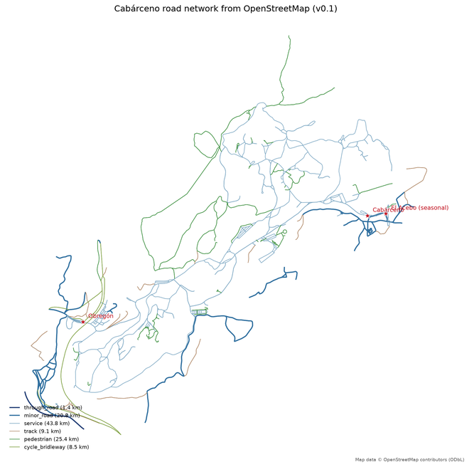
The animals come from the official March 2026 visitor map — names and numbers only, which are facts, not cartography. 30 of the 33 numbered entries were matched by hand to an OpenStreetMap feature.
The viewing points are derived, never invented: for each enclosure polygon, the closest point on the nearest drivable road, with the road split there so it becomes a real stop. 34 of 36 are within 35 m of tarmac, which fits a park where you are asked to stay in the car.
The ordering is a travelling-salesman problem solved with OR-Tools — over road-network distances from Dijkstra, never straight lines. That distinction is not pedantic here: two paddocks 200 m apart across a fence can be 3 km apart by road, and some park roads are one-way, so the worst A→B versus B→A pair in this data differs by nearly 4 km.
Then the honest part. A tour that looks perfect on a distance matrix can still send you down the same lane four times, because the matrix hides which roads each leg uses. So every route is expanded back onto real OpenStreetMap edges and measured:
repeated metres = Σ max(0, times driven − 1) × segment length
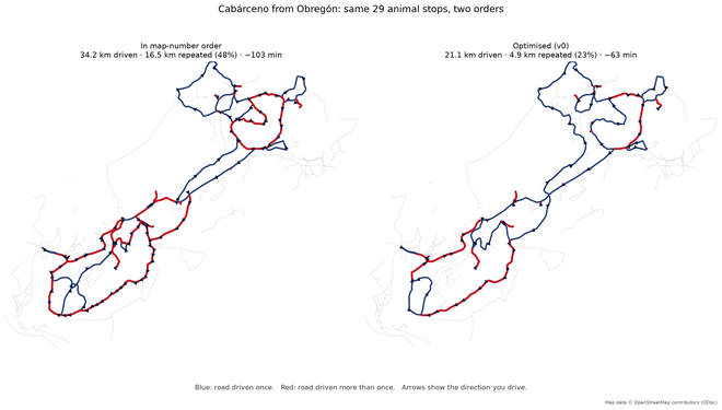
Red is road driven more than once. Same park, same animals, two orders. Almost all of the extra 13.1 km is that red.
See the two side by side, interactively · the naive map-number route on its own · the raw OSM audit map
What I should not trust#
The times are assumptions. Distances are solid — they are OpenStreetMap geometry. Driving times are distance ÷ speed, capped at the park’s own 30 km/h. But every dwell time is a guess: five minutes per enclosure, forty for a meal, seven for a toilet. Five minutes × 29 enclosures is 3h00 of the ~4h03 day, so that one made-up constant dominates the answer. If we really spend three minutes at the cows and twenty at the elephants, the whole plan shifts.
It is not the official recommended route, and I cannot say I beat it. The park does draw a recommended itinerary — but as a line on the map artwork, not as the 1→33 numbering, which is only a legend index. Tracing that line would mean copying copyrighted cartography, so the comparison above is against visiting in map-number order. That is a fair stand-in for an unplanned visit, and it is the only claim made.
Three things on the official list are missing: Dromedario, Aula Medioambiental, Sala 360º, Casa Oso Pardo, (unlabelled on the 2026-03 map). They have no OpenStreetMap feature to attach to, and I would rather leave them out than invent coordinates. The route visits 29 of the animal areas, not all of them.
The road rules come from OpenStreetMap, not from the park. 655 of the 862 drivable segments were included on weak evidence — service roads, tracks, or no access tag at all. One-way restrictions may be missing or wrong. If a sign contradicts the map, the sign wins. This route has never been driven.
Opening hours are not modelled at all, so the panel can cheerfully suggest a restaurant that is shut. The birds-of-prey demonstration is in the plan as a fixed 40-minute cost, but the model has no idea when the shows actually are — that needs time windows, which is the next piece of work.
Congestion is not modelled. Twenty cars stopped at the elephants is the normal state of that road in August and nothing here knows about it.
It is a heuristic, not a proof. OR-Tools returns a very good tour, not a guarantee that none is better. Several tours tie exactly on distance while differing in where lunch falls — the solver picks one, and that choice is currently arbitrary.
Tomorrow’s checklist#
- Open the Obregón map before leaving; the tiles cache, but do not count on signal.
- Press ⊙ once in the car park so the browser asks for location while you still have patience for it.
- Check the birds of prey show times on arrival — the plan puts it in but does not know the timetable.
- If starting from El Acebo instead, confirm it is actually open.
- Treat the Detours tab as the “we are running late” lever, not the plan.
- Obey the signs, not me.
Data, licence, reproducing#
Map data © OpenStreetMap contributors, available under the ODbL. Animal names and numbering are facts taken from the park’s own March 2026 visitor map; no cartography was copied, and no coordinate here came from a proprietary source.
OSM snapshot 2026-08-09T23:11:30+00:00, extracted with OSMnx 2.1.1. The whole pipeline —
extraction, graph derivation, matching, solving, these maps and this post — regenerates
from scripts.
Next: let each enclosure be satisfied by any of its viewpoints instead of one fixed point; time windows for the show and for lunch; and best-value routes for a two- or three-hour visit rather than the full circuit.